
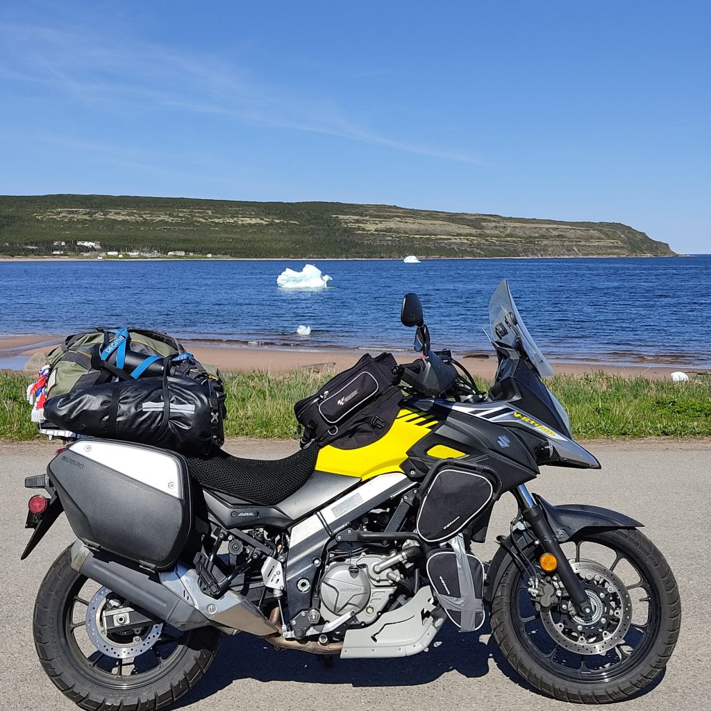
Going on a roadtrip is not only getting amazed by wonderful landscapes and the freedom which goes along. It is also an opportunity to discover a culture ; a history ; whether told by the people who live there, or by the monuments still standing and maintained, or even by the geological formations that have been preserved and documented. Canada, as we know it today, is considered a young country. I heard it many times. Yet this land was shaped thousands of years ago and inhabited by different peoples down the ages. This is what I discovered after 30,000 kilometers of motorcycling. For this first part of the History and Culture of Canada series, let me take you on a tour in Newfoundland and Labrador through some interesting facts you may have never heard of.
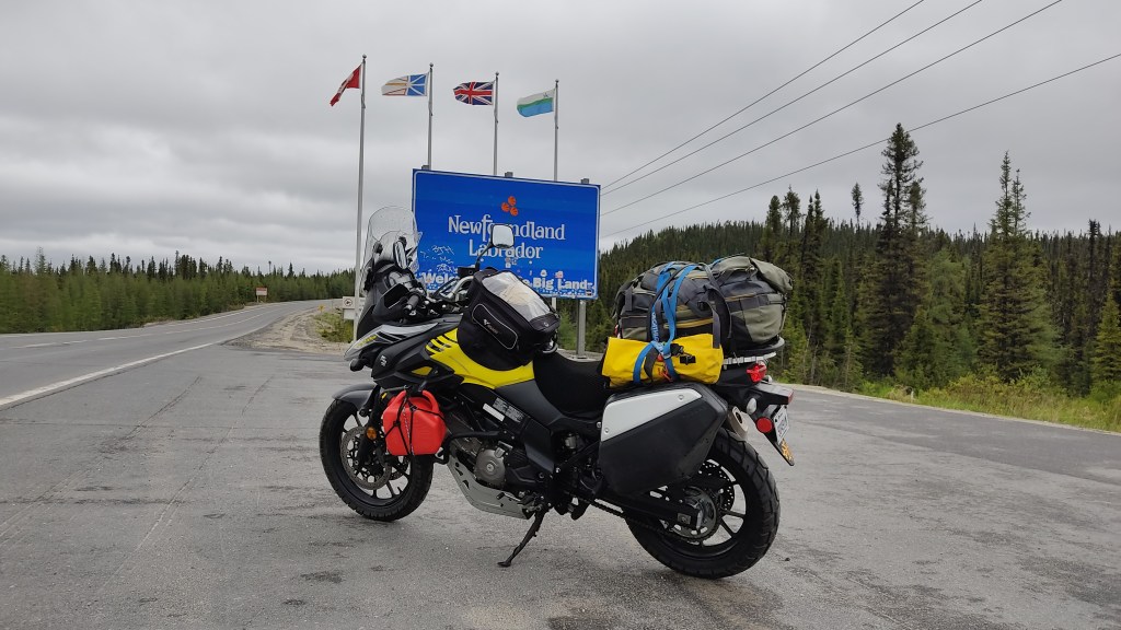
The island of Newfoundland alone is not a province. Together with the Labrador Peninsula, it forms Canada’s tenth province, and was renamed Newfoundland and Labrador in 2001. Labrador was attached to the island in 1927, after a long dispute between Canada and the British Empire. And in 1949, after two referendums on self-determination, Newfoundland and Labrador became part of Canada. Until then, Newfoundland had been a Dominion of the British Crown. Today, the province has a population of around 530,000, 94% of whom live on the island.
Fun fact: Newfoundlanders are nicknamed Newfies, and are considered the most hospitable and altruistic people in the country. After 10 days in the territory, let me say that, yes, it is true !
From the Vikings to Jean Cabot, European colonization of the island of Newfoundland
Long before the arrival of French and English settlers, the Vikings set foot on the island of Newfoundland, precisely at l’Anse-aux-Meadows (a UNESCO World Heritage Site since 1978). Archaeological digs have uncovered traces of an ancient village and unearthed numerous artifacts. We date their arrival around 1021. Reconstructions show that these Norsemen, also known as Northmen or Normans, were not interested in long-term settlement, but rather in the search for raw materials such as wood, which were not available in Greenland.
However, it seems that these exploratory warriors chose to continue their discovery of these new lands, in search of resources. The Viking Trail, which is over 500 kilometers in length, traces their progress. It takes you from St Anthony, a village made famous by its lighthouse, to Gros Morne National Park, which invites you to discover a majestic fjord. Along the way, it’s hard to miss Port-au-Choix, one of the oldest French-speaking communities; or the geological formation known as « les Arches », shaped on the ancient limestone coastline by the force of the waves. At low tide, you can even walk under these arches!
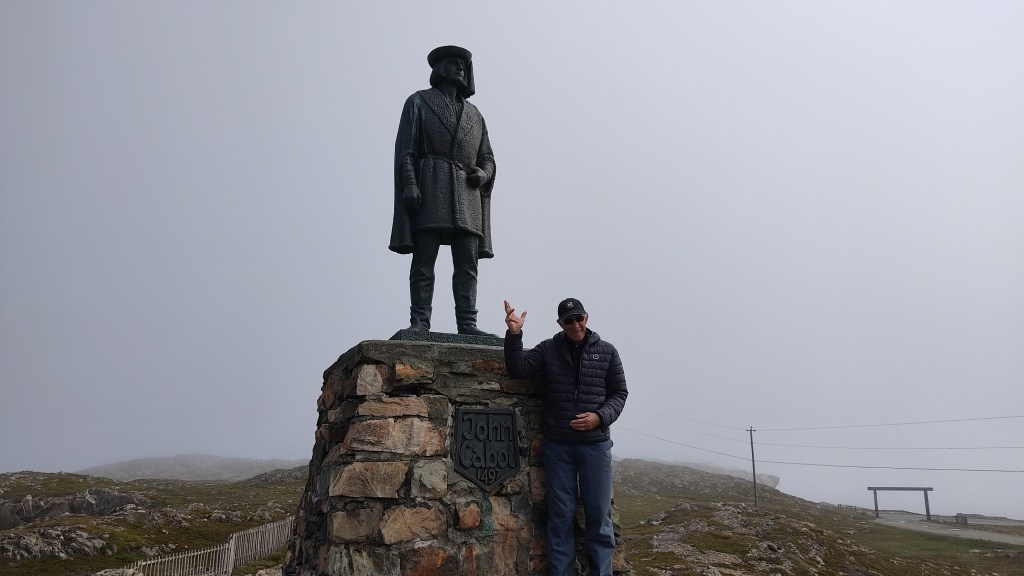
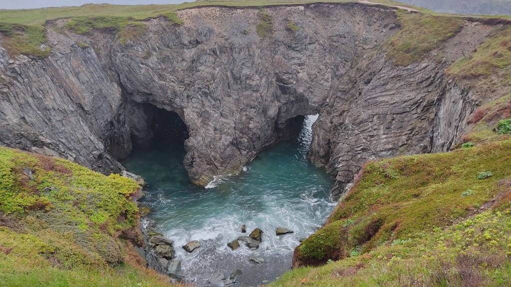
To continue our discovery of the island through the prism of European colonization, let’s head East. Our next stop is Bonavista. The village was made famous by Jean Cabot. Originally named Giovanni Caboto, the Venetian explorer even claimed responsibility for the discovery of North America. And that’s just the beginning. The year was 1497. Legend has it that he exclaimed « Buon vista ! » as soon as he disembarked from his ship, thus giving his name to the place, Bonavista. The village, now home to some 3,500 inhabitants, still relies on fishing and tourism. In addition to the statue of the navigator and the life-size replica of his ship, Bonavista is a must for wildlife-watching, as it is home to one of the country’s largest puffin colonies. No need for an excursion; just a snack, binoculars (or just your eyes) and a little patience, and you’ll have plenty of time to observe these amazing birds. In early summer, you can also follow the descent of the icebergs along the coast and enjoy the ballet of the many whales, whose migration continues over several weeks. Less than two kilometers from the Bonavista lighthouse, you’ll also come across another example of what nature has to offer: the Dungeon Provincial Park. Carved out by the waters, an arch with two bridges forms a cavity where the water rushes in and out. A phenomenon that tourists and locals alike are never tired of observing. The Bonavista Geopark has even been awarded the precious UNESCO Geopark label in 2020.
A Basque community in Labrador, really?
You read that right. In the 16th century, many years after the Vikings first discovered Labrador and Newfoundland, and after the arrival of the first European colonies, Basque fishermen decided to settle on the northeast coast of Labrador (and Quebec). The epicenter of the industry, however, is the village of Red Bay. It wasn’t cod, abundant in the Labrador Sea, that really motivated this settlement, but rather the presence of whales. Whale oil was highly sought-after in Europe, used as a source of energy for lamps or to make soap. As a result, French-speaking Basques and Spanish controlled fishing on the northeast coast for almost a century.
Red Bay has been a Canadian historic monument since 1979 and a UNESCO World Heritage Site since 1913. Numerous relics of this era can be found here, and the Boney Shore trail offers breathtaking views of the village, Saddle Island and the vastness of the Labrador Sea. Bonus: an exceptional view of the icebergs. And if you’re a gourmet, I recommend the fish and chips at Whaler’s Restaurant, considered the best on the Atlantic coast. You can enter the restaurant with your eyes closed. Everything is homemade, and you almost feel as if you’re there.

Unexpected fame for Gander and its airport
Gander is a small Newfoundland town of 12,000 inhabitants, about 100 km from the tourist villages of Twilingate and Bonavista. Although a medium-sized town, it has its own international airport, Gander International Airport, built in 1935 and chosen for its strategic position on the London-New York route, which enabled planes to refuel for the crossing between the old and new continents. It was the presence of this airport that gave the city its new renown. On September 11, 2001, shortly after the attacks on the Twin Towers, North American airspace was closed by Canadian and American authorities, leaving some 40 aircraft in limbo. Where to land safely? The Canadian Prime Minister of the time proposed Gander International Airport as the only viable solution. Nearly 7,000 passengers and crew made emergency landings, waiting for airspace to become operational again. For a week, they were housed, fed and cared for by the town and its people, enjoying the legendary hospitality of Newfoundlanders.
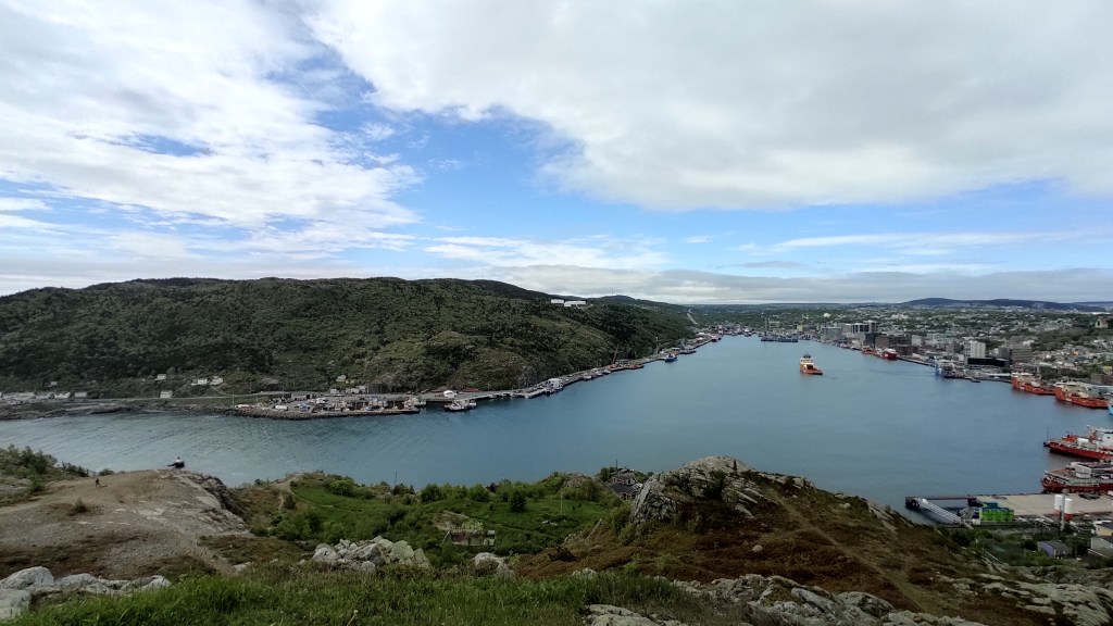
Signal Hill in St. John’s, forerunner of today’s communications
St. John’s is the capital of the island of Newfoundland. Dynamic and attractive, it owes its name to John Cabot, who is said to have discovered it. So, in addition to being North America’s most easterly city, it’s also one of the continent’s oldest European colonies. When you wander around, you’ll feel like you’re in San Francisco for a brief moment. Or, at the very least, you’ll see photos of the Californian city flash before your eyes: steep hills, steep streets and colorful houses that bear witness to the settlement of the colonists – the parallels are striking. But it wasn’t Saint-Jean that intrigued me, rather Signal Hill, the hill overlooking the city. The attraction even ranks 3rd on TripAdvisor, with a rating of 4.2/5. Can’t miss it, eh? A breathtaking view of the city and its surroundings, an assortment of footpaths to admire the coastline, and a rich history: the cocktail has it all.
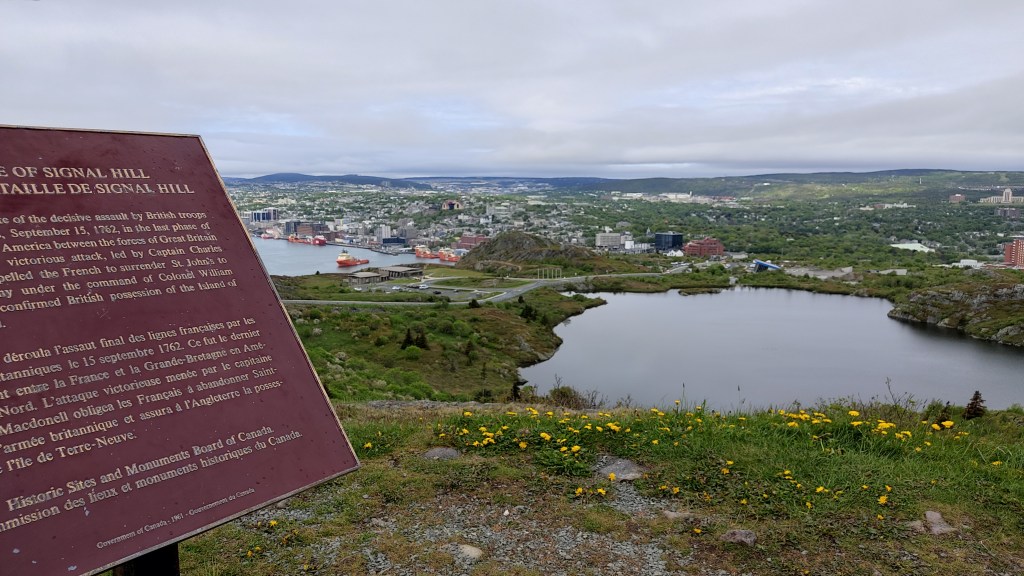
Let’s go back in time. Do you know about the Battle of 7 Years? Once again, the French and the English were at war. This time, the battle took place on several fronts, in Europe, the Americas and Asia, and involved various alliances, between France and Spain against England and Prussia. The conflict began in 1756 and ended in 1763. And it was precisely here, at Signal Hill, on September 15, 1762, that the American theater of the conflict came to an end, with an English victory. Don’t let our patriotic feelings get the better of us, the English were more cunning. Or reckless. Or both.
Earlier in 1762, the French army, led by Comte d’Haussonville, surrendered the English forces at Saint-Jean. Signall Hill is a strategic point of attack and defense. Its elevated position enabled French troops to keep a watchful eye on both sea and land. The watchtower was reinforced with heavy artillery and troops were added to the existing garrison. However, this was not enough to prevent a surprise attack by the English army. On September 15, 1762, the English stormed the hill. 300 French soldiers were killed, and the remainder – about twice as many – were forced to retreat to Fort Williams, in the heart of Saint-Jean, abandoning the strategic position and all their armaments. Three days later, the vanquished had no choice but to surrender. And that was the end of the beans for France, which let Great Britain become the dominant power in North America. The summary is succinct, but I encourage you to read more on the subject.
The other interesting element, which doesn’t always feature in school textbooks (or which you may have forgotten, like me), is Signal Hill’s role in the history of telecommunications. You could even say it’s the place where everything began for today’s communications. On December 12, 1901, Signall Hill received the first transatlantic signal: three beeps which, in Morse code, correspond to the letter S. Italian inventor and physicist Guglielmo Marconi is credited with this achievement. In 1896, he designed a machine capable of transmitting and receiving a long-distance signal using Morse code. He successfully carried out a test between France and England, over the English Channel. He wanted to test his invention over a longer distance, this time over the Atlantic Ocean. He positioned his transmitting station in Cornwall, England, and the receiving station in Cape Cod, Massachusetts. However, a storm damaged the former, which had to be replaced by a shorter-distance transmitting station. The inventor swapped the Cape Cod receiving station for Saint-Jean-de-Terre-Neuve, more precisely in the hospital built on the heights of Signal Hill.
Although the hospital has long since disappeared, you can still visit the Watchtower and its museum to learn more about this historic site.

| How to get to Newfoundland ? By sea: A ferry links Sydney, in Cape Breton, to Newfoundland. You can choose between Port-aux-basques on the southwest coast (7-hour crossing) or Argentia on the east coast (16-hour crossing). On the Labrador side, you can take the ferry that links the island to the mainland, between St Barbe (Newfoundland) and Blanc-Sablon (Quebec), just a few kilometers from Labrador’s first town, L’Anse-au-Clair. By road : You can enter Labrador through Quebec only. To the west of the province, Quebec Route 389 joins Labrador Route 500, between Fermont and Labrador City. To the east, Quebec Route 138 becomes Labrador Route 510, linking Blanc-Sablon (Quebec) to L’Anse-au-Clair (Labrador). This route is legendary and part of Expedition 51. By air: Labrador has two airports: Wabush and Happy-Valley-Goose-Bay. The island has two international airports, St. John’s and Gander, and three others with links to the mainland: St Anthony, Deer Lake and Stephenville. You could also land in Blanc-Sablon (Quebec) before taking the ferry to the island or renting a car to explore Labrador. How to get around? On foot, by bike, by motorcycle, by car. Newfoundland has an abundance of trails to explore, and the secondary roads leading off the Trans-Canada Highway are a delight for cyclists and motorcyclists alike. If you prefer to drive, remember to book your rental in advance, as demand is understandably high at the height of the season. In Labrador, the only road that crosses the region is a « must-do » for all lovers of wilderness roadtrips, promising grandiose views and a real sense of fulfillment. Don’t forget your jerrycan between the 430 kilometers between Happy-Valley-Goose-Bay and Port-Hope-Simpson, as there are no services (cell phone, supermarket, gas station). To make sure you don’t miss a thing and prepare for your visit, the Newfoundland and Labrador tourist information site is full of tips. An interactive map will help you prepare for your visit. You can also order the printed guide in advance. |
To read it in French, click here.

Laisser un commentaire